

Are you ready to witness the world change right before your eyes? With FusionMap’s groundbreaking SplitViewer feature, you can now experience time travel without leaving your desk. This innovative tool allows you to compare two satellite images from different dates side by side, giving you an unparalleled view of how landscapes evolve over time. See…
Category: Remote Sensing

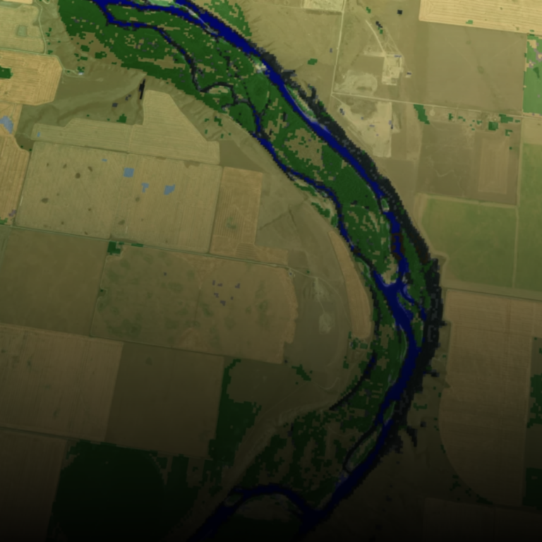
Transforming Flood Prevention: FusionMap’s Water Detection Solution
Flooding has long been a recurring and financially burdensome challenge for businesses across diverse industries. However, with the advent of the latest web-based technology, a formidable ally has emerged in the battle against this relentless natural threat. Let’s delve into FusionMap, the sophisticated data management platform meticulously crafted by Tetra Tech. This platform promises not…
Navigating the Waters: How FusionMap’s Satellite Technology Revolutionizes Water Hazard Monitoring
In an increasingly unpredictable climate, the challenge of protecting linear infrastructure from water-related hazards is paramount. Roads, pipelines, and power lines are the lifelines of our communities, and their safety and integrity are non-negotiable. FusionMap has risen to this challenge, harnessing the power of satellite technology combined with AI-driven insights to offer a groundbreaking solution…

Leveraging SAR Data and FusionMap to Assess Damages from Catastrophic Dam Failure in Eastern Ukraine
In the face of natural disasters like dam failures, timely and accurate information is critical for decision-makers, emergency responders, researchers, and citizens alike. The recent catastrophic dam failure in Eastern Ukraine underscores the importance of advanced technologies in assessing damages and managing the aftermath of such events. In this blog post, we’ll explore how satellite…

Revolutionizing Disaster Management with FusionMap: A Game-Changer for First Responders
In an ever-changing world, the ability to respond swiftly and effectively to natural disasters is paramount. Lives, property, and entire communities often hang in the balance. That’s where FusionMap comes in—a revolutionary platform that harnesses the power of high-resolution Synthetic Aperture Radar (SAR) data to empower disaster management and first responders. The Power of FusionMap:…

Discover the Future of Mapping with FusionMap™
In a world where data is king, FusionMap™ emerges as a cutting-edge web-based application, redefining the way we interact with geospatial information. With the ability to consolidate data from diverse sources into one unified platform, we’re breaking down the barriers to accessibility and collaboration. Our latest major upgrade introduces a game-changing 3D layer, designed to…

How FusionMap and AI are Transforming Geospatial Data in Maui
In the face of natural disasters, innovation becomes the key to resilience and recovery. In the lush paradise of Maui, Hawaii, wildfires have become an increasing threat, endangering both the island’s stunning natural beauty and the communities that call it home. However, hope is on the horizon, thanks to the ground breaking efforts of Tetra…
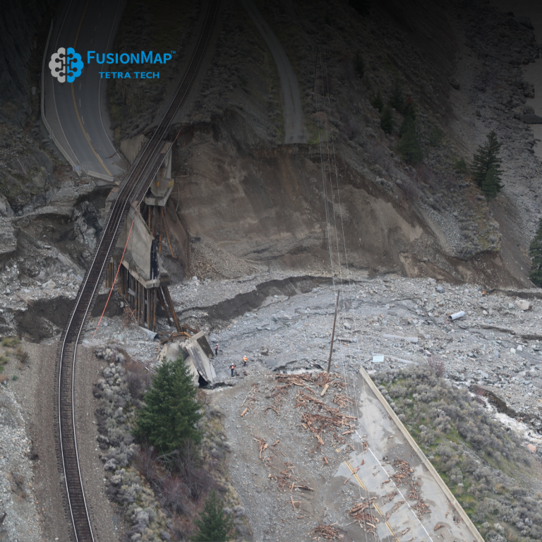
Geohazard Recognition and Mapping with FusionMap
FusionMap harnesses the strengths of LiDAR technology, capable of capturing high-resolution 3D data of terrain and vegetation cover, and combines it with AI technology for efficient and intelligent data processing and analysis.

“Unveiling the Power of FusionMap™: A Unified Platform for Privacy and Advanced AI Technology”
In today’s data-driven world, businesses and organizations face the challenge of integrating and managing diverse data sources efficiently. FusionMap™ emerges as the answer to this growing need, offering a cutting-edge web-based application that brings together data from various origins into a single, unified platform. With built-in support for multiple users, tenants, and administrative features, it’s…
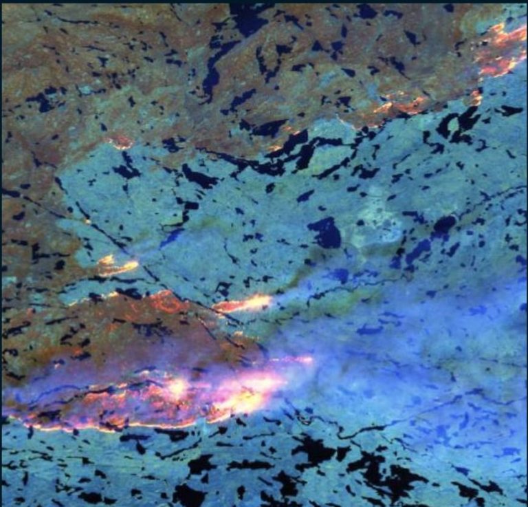
From Sky to Ground: Tracking Wildfires with FusionMap’s Satellite Multispectral Technologies
Tracking the Progress of Wildfires Using Satellite Multispectral Technologies in FusionMap
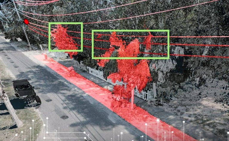
Vegetation Management and Power Utility Clearance Assessments with FusionMap
Vegetation encroachment poses significant risks to power utility infrastructure, including increased outage incidents and safety hazards. FusionMap empowers asset managers by offering advanced vegetation management capabilities: